
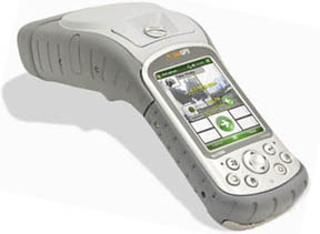
ikeGPS is a mobile GIS data capture device that allows the user to locate and measure remote objects and transfer the data to mapping systems and workflow applications like VMSuite. ikeGPS captures:
- The target GPS position
- The distance to the target via the laser rangefinder
- The bearing and relative altitude of the object via a 3D compass
- A high resolution photo of the target, with cross hairs embedded in the image to verify the exact point of measurement
- A TrueSize image of the vegetation target that can be measured via on-board photogrammetry software
ikeGPS is offered as a standalone device, and it can be bundled with VMSuite for a complete, integrated vegetation management workflow. ikeSolutions UVM including ikeFlow workflow software
enable quick, data-rich tree inventories, pole inventories, inspection and post-storm assessments, and more. All of
the data captured can be exported into multiple data file types that integrate into ESRI, Google Earth and all other major mapping and backend systems.
When synced with the PlannerVM software application, data can be augmented with circuit identification, digital signatures, assessment and prescription,
crew assignments, and even LIDAR datasets. Data rich work orders are then generated, along with spreadsheets, route maps, and detailed site maps. All of
this is made available on InsightVM for utility foresters and management to view detailed analysis of the system, including reports, circuit snapshots,
real-time crew locations, and with the addition of RealTimeVM, cost estimates.
For more information or to order an ikeGPS with ikeSolutions UVM, please contact us.